Course
The Kokava Trail race course with start and finish place in Kokava nad Rimavicou is located in the Veporské and Stolické vrchy mountains in Slovakia. The course is certified by ITRA (3 points).
Course parameters, course map, GPX file and course profile:
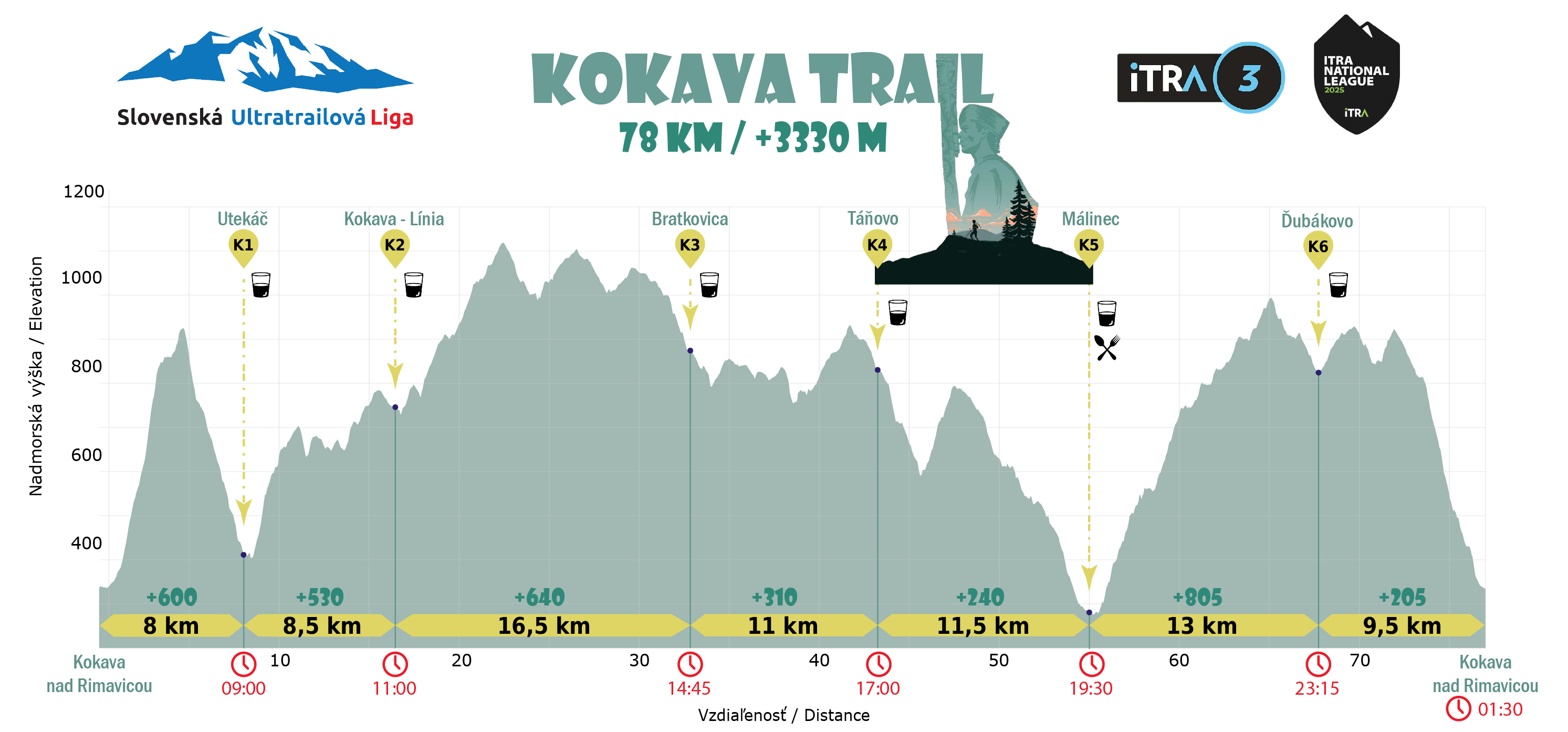
78 km (distance) / +3330 m (total elevation gain)
Online course map on TuristickaMapa.sk
(use this link for Freemap.sk)
GPX file for download (please use this file, not an export from the online course map)
Course description (including tourist marking colours):
Green tourist mark:
Kokava nad Rimavicou, námestie (square) => Slopovo, Laz => Sedlo Langovo
Local yellow tourist mark:
Sedlo Langovo => Utekáč => Sedlo Kvandovo
Blue tourist mark and own course marking:
Sedlo Kvandovo => Pod Grúňom => Kokava - Línia => connection to the red tourist mark close to the Drahová summit
Red tourist mark:
Connection to the red tourist mark close to the Drahová summitn => Drahová, vrchol => Čierťaž, rázcestie => Prameň Ipľa (odbočka) => switch to the blue tourist mark
Blue tourist mark:
Switch to the blue tourist markodrú TZ => Bratkovica => Pod Lipovým vŕškom
Local tourist marking and own course marking:
Pod Lipovým vŕškom => connection to the road nr. 526 => turn right to the yellow tourist mark => connection to the yellow tourist mark
Local yellow tourist mar and own course marking:
Connection to the yellow tourist mark => Chocholná
Red tourist mark:
Chocholná => Smolno => Táňovo, rázcestie => Sedlo Prieraz
Green tourist mark:
Blue tourist mark:
Šutova jama => Pod Soliskom => Málinec
Red tourist mark:
Málinec => Brložno => Jasenina => Sedlo nad Ďubákovom => Ďubákovo
Local tourist marking and own course marking:
Ďubákovo => Ďubákovo, aid station => Ďubákovo
Red tourist mark:
Ďubákovo => Diel => Kokava nad Rimavicou, námestie
Aid stations:
There will be aid stations with refreshments placed on the course. In the same places there will be also the checkpoints with electronic timekeeping. Here is the list of Kokava Trail race aid stations/checkpoints including the link for online map, distance from start and time limit information.
-
K1 Utekáč - next to the Hostinec v horách pub (8. km) - time limit: Saturday 5. September 2026 until 09:00 CET
-
K2 Kokava - Línia - Family boarding house (16,5. km) - time limit: Saturday 5. September 2026 until 11:00 CET
-
K3 Bratkovica (33. km) - time limit: Saturday 5. September 2026 until 14:45 CET
-
K4 Táňovo - cabin (44. km) - time limit: Saturday 5. September 2026 until 17:00 CET
-
K5 Málinec - culture house (55,5. km)- time limit: Saturday 5. September 2026 until 19:30 CET
-
K6 Ďubákovo - Informačné centrum (68,5. km) - time limit: Saturday 5. September 2026 until 23:15 CET
Terrain:
The course, as it is usual by mountain ultramarathons, is a multi-terrain one. Significant are the large meadows. Forest paths and trails are making another part of the course. The tarmac (asphalt roads) makes about 10% of the 78 km course, the longest tarmac passage with 1,2 km is the course beginning in Kokava nad Rimavicou. There are no really technically difficult passages, but please, calculate with several steep ascents and descents.
The race organizer reserves the right to change the course, time limits of the checkpoints. In such case the registered participants will be informed via e-mail.
Course profile (for zoom - click on the picture):
Course conditions and warnings:
Information will be added in the week before the race.